Contour Survey (কন্ট্যুর সার্ভে)
Contour Survey
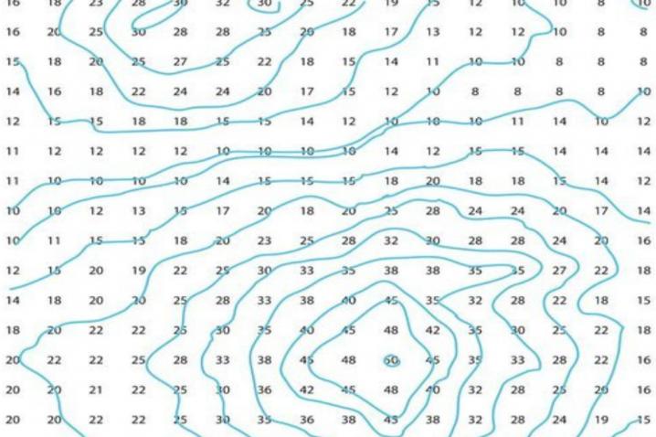
Contour line
The line of intersection of a level surface with the ground surface is known as the contour line or simply the contour. It can also be defined as a line passing through points of equal reduced levels.
For example, a contour of 100 m indicates that all the points on this line have an RL of 100 m. Similarly, in a contour of 99 m, all points have an RL of 99 m, A map showing only the contour lines of an area is called a contour map.
Contour Interval
The vertical distance between any two consecutive contours is known as a contour interval. Suppose a map includes contour lines of 100 m, 98 m, 96m, and so on. The contour interval here is 2 m. This interval depends upon: (i) the nature of the ground (i.e. whether flat of steep), (ii) the scale of the map, and (iii) the purpose of the survey.
Contour intervals for flat country are generally small, e.g.0.25 m, 0.50 m, 0.75 m, etc. The contour interval for a steep slope in a hilly area is generally greater, e.g. 5 m, 10 m, 15 m, etc.
Again, for a small-scale map, the interval may be of 1 m, 2 m, 3 m, etc, and for large scale map, it may be of 0.25 m, 0.50 m, 0.75 m, etc.
It should be remembered that the contour interval for a particular map is constant. Horizontal equivalent
The horizontal distance between any two consecutive contours is known as horizontal equivalent. It is not constant. It varies according to the steepness of the ground.
For steep slopes, the contour lines run close together, and for flatter slopes they are widely spaced.OBJECT OF PREPARING CONTOUR MAP
The general map of a country includes the locations of roads, railways, rivers, villages, towns, and so on. But the nature of the ground surface cannot be realized, from such a map.
However, for all engineering projects involving roads, railways, and so on, a knowledge of the nature of ground surface is required for locating suitable alignments and estimating the volume of earth work.
Therefore, the contour map is essential for all engineering projects. This why contour maps are prepared.
A contour may be defined as a line of intersection of a level surface with the surface of the ground. This means every point on the contour line has the same altitude as that of the assumed intersecting surface.
The process of tracing contour lines on the surface of earth is called contouring. A contour map gives the idea of the altitudes of the surface features as well as their relative positions in a plan.
আমাদের সেবা সমূহ:
· ভূমি/জমির ডিজিটাল সার্ভে / টপোগ্রাফিক সার্ভে / ডিজিটাল সার্ভে / ল্যান্ডস্কেপ ডিজাইন - Land Digital Survey/ Topographical Survey/ Landscape Design.
· ডিজিটাল সার্ভের মাধ্যমে মৌজা ম্যাপের জমির ও ভবনের অবস্থান নির্ণয়- Digital Survey on the Mouza Map & Map Produced on the Mouza Map/Identify Land which is in Possession on the Map
· ড্রেনেজ, পাইপ লাইন রুট, রোড,ব্রীজ ও ফ্লাইওভার সার্ভে- Road & River Survey, Railway & Airport Survey, Bridge & Darn/ Canals Survey, Hill & Plant/Tree Survey
· ভূমি অধিগ্রহণ প্ল্যান ও দাগসূচী- Land acquisition plan and schedule
· অ্যাজ বিল্ড প্ল্যান (এস বিল্ট সার্ভে)- As Built Plan
· কন্ট্যুর সার্ভে- Contour Survey
· Calculation
· প্রপার্টি ভ্যালুয়েশন / সম্পত্তি মূল্যায়ন প্রতিবেদন- Asset/Property Valuation, Property Valuation for Immigration / Tourist Visa / Student Visa/ Investor/ Embassy purpose, Land Valuation, Building & Apartment Valuation, Factory Valuation, Machinery Valuation, Vehicle Valuation, Vessel Valuation, Power Plant Valuation
· লে-আউট (পাইল, কলাম, গ্রীড, রোড, ব্রীজ, ফ্লাইওভার)- Layout & Alignment of Building, Road, Bridge, Culvert, Embankment, Canals etc.
· লেভেল সার্ভে (pre & post work)- Volume calculation of earth cutting and filling for development work, Layout & Alignment of Building, Road, Bridge, Culvert, Embankment, Canals etc.
· প্লটিং (যে কোনো আকৃতির জমি পরিমাপের প্লটিং করা)- Plotting
· ডিজিটাল সার্ভে দ্বারা জমি সঠিক ভাবে বন্টন বা ভাগ করা- Proper distribution of land by digital survey
· সয়েল টেস্ট ও পাইলিং - Geotechnical Investigations (Soil Test), Piling
· আর্থ ভলিউম ক্যালকুলেশন (মাটি কাটা বা ভরাটের পরিমাণ বের করা)- EARTH VOLUME CALCULATION
· অটোক্যাডের মাধ্যমে মেীজা ম্যাপ ডিজিটাল এ রূপান্তর- Mouza map digital conversion through AutoCAD
· মৌজা ম্যাপ পেন্টাগ্রাফ (মৌজা ম্যাপের উপর মৌজা ম্যাপ প্রতিস্থাপন) করা- Making Mouza map pentagraph (substituting Mouza map over Mouza map).
· মৌজা ম্যাপ সি.এস, আর.এস, বি.এস সুপার ইম্পোজ - Mouza map CS, RS, BS superimpose
· মানচিত্র মৌজা ম্যাপ জিওরেফারেন্সিং ও ডিজিটাল ডিজিটাইজেশন করা - Maps Georeferencing and digital digitization of maps.
v বাংলাদেশের যেকোনো প্রান্তের মৌজা ম্যাপ সরবরাহ করা হয়। - Mouza map supply of any part of Bangladesh
প্রয়োজনে কল করুণ আমাদের হটলাইন নম্বর এ ফোনঃ01715118895 (If necessary, call our hotline number:01715118895)
Real Survey Inspection (রিয়েল সার্ভে ইন্সপেকশন)
House No. 19 (4th Floor)
Road No. 08, Block- H
Mirpur- 02, Dhaka- 1216
Cell: 01715118895
E-mail: [email protected]
Web: www.realsurveyinspection.com
আমাদের সেবা সমূহ:
· ভূমি/জমির ডিজিটাল সার্ভে/ টপোগ্রাফিক সার্ভে
· প্রপার্টি ভ্যালুয়েশন / সম্পত্তি মূল্যায়ন প্রতিবেদন
· ডিজিটাল সার্ভের মাধ্যমে মৌজা ম্যাপের জমির ও ভবনের অবস্থান নির্ণয়
· লে-আউট ও প্লটিং
· আর্থ ভলিউম ক্যালকুলেশন (মাটি কাটা বা ভরাটের পরিমাণ বের করা)
· সয়েল টেস্ট ও পাইল
· মৌজা ম্যাপ পেন্টাগ্রাফ (মৌজা ম্যাপের উপর মৌজা ম্যাপ প্রতিস্থাপন)
- BASIC SERVICES
- Road Survey
- Railway Survey
- Airport Road Survey
- Dam Survey
- Bridge Survey
- Hill Survey
- River Survey
- Engineering Survey
- Pipeline Survey
- Topographical Survey
- Land Survey
- Cad-astral Survey
- GPS, RTK, DGPS Survey
- Final Location Survey
- Contour Survey
- Drawing Digitization
Published on: Thursday, 12 May 2022, 07:59 pm | Last update: Thursday, 17 August 2023, 12:27 pm | Total views: 3609.


CATEGORIES
PAGES
- Our Services
- Land Digital Survey / Topographical Survey / ল্যান্ড সার্ভে (ভূমি/জমির ডিজিটাল সার্ভে/ ডিজিটাল সার্ভে)
- SOIL TEST (সয়েল টেস্ট) & PILING (পাইল)
- Architectural Design (আর্কিটেকচারাল ডিজাইন) & As Built Plan (অ্যাজ বিল্ট প্ল্যান)
- Property Valuation প্রপার্টি ভ্যালুয়েশন (সম্পত্তির মূল্য নির্ধারণ করা)
- Valuation Certificate for Foreign Visa প্রপার্টি ভ্যালুয়েশন ফর ভিসা (ভিসা ফাইলের জন্য সম্পত্তি মূল্যায়ন)
- Flat & Floor Measurement অ্যাপার্টমেন্ট মেজারমেন্ট/ফ্লোর মেজারমেন্ট and Deviation Calculation
- Plotting and Layout (প্লাটিং / লে-আউট)
- Comparing Google Map, C.S., R.S. BRS Mouza Map & Identify land which is in possession on the map, Pantograph / Comparing Mouza Map মৌজা ম্যাপ পেন্টাগ্রাফ (মৌজা ম্যাপের উপর মৌজা ম্যাপ প্রতিস্থাপন), মানচিত্র/ মৌজা ম্যাপ ডিজিটাল ডিজিটাইজেশন
- GPS Survey (জিপিএস সার্ভে)
- Hydrographic Survey (হাইড্রোগ্রাফিক সার্ভে)