Leveling Survey/ Spot Level Survey/ RL/ Earth Volume calculation, Cutting and Filling, আর্থ ভলিউম ক্যালকুলেশন (মাটি কাটা বা ভরাটের পরিমাণ বের করা)
Leveling Survey/ Spot Level Survey/ RL/ Earth Volume calculation, Cutting and Filling, আর্থ ভলিউম ক্যালকুলেশন (মাটি কাটা বা ভরাটের পরিমাণ বের করা)
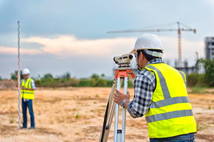
Leveling Survey/ Spot Level Survey/ RL/ Earth Volume calculation, Cutting and Filling
Object
The aim of leveling is to determine the relative heights of different objects on or below the surface of the earth and to determine the undulation of the ground surface.
Uses of Leveling Survey
· Leveling is done for the following purposes:
· To prepare a contour map for fixing sites for reservoirs, dams, barrages, etc., and to fix the alignment of roads, railways, irrigation canals, and so on.
· To determine the altitudes of different important points on a hill or to know the reduced levels of different points on or below the surface of the earth.
· To prepare a longitudinal section and cross-sections of a project (roads, railways, irrigation canals, etc) in order to determine the volume of earth work.
· To prepare a layout map for water supply, sanitary or drainage schemes.
DEFINITIONS
· Levelling is done for the following purposes:
· Levelling The art of determining the relative heights of different points on or below the surface of the earth is known as leveling. Thus, leveling deals with measurements in the vertical plane.
· Level surface Any surface parallel to the mean spheroidal surface of the earth is said to be a level surface. Such a surface is obviously curved. The water surface of a still lake is also considered to be a level surface.
· Level line Any line lying on a level surface is called a level line. This line is normal to the plumb line (direction of gravity) at all points
· Horizontal plane Any plane tangential to the level surface at any point is known as the horizontal plane. It is perpendicular to the plumb line which indicates the direction of gravity
· Horizontal line Any line lying on the horizontal plane is said to be a horizontal line. It is a straight line tangential to the level line
· Vertical line the direction indicated by a plumb line (the direction of gravity) is known as the vertical line. This line is perpendicular to the horizontal line
· Vertical plane Any plane passing through the vertical line is known as the vertical plane.
· Datum surface or line This is an imaginary level surface or level line from which the vertical distances of different points (above or below this line) are measured. In India the datum adopted for the Great Trigonometrically Survey (GTS) is the mean sea level (MSL) at Karachi.
· Reduced level (RL) The vertical distance of a point above or below the datum line is known as the reduced level (RL) of that point. The RL of a point may be positive or negative according as the point is above or below the datum.
· Line of collimation It is an imaginary line passing through the intersection of the cross-hairs at the diaphragm and the optical centre of the object glass and its continuation. It is also known as the line of sight.
· Axis of the telescope This axis is an imaginary line passing through the optical centre of the object glass and the optical centre of the eye-piece.
· Axis of bubble tube It is an imaginary line tangential to the longitudinal curve of the bubble tube at its middle point
· Bench-marks (BM) These are fixed points or marks of known RL determined with reference to the datum line. These are very important marks. They serve as reference points for finding the RL of new points or for conducting leveling operations in projects involving roads, railways, etc.
Bench-marks may be of four types: (a) GTS, (b) Permanent, (c) temporary, and (d) arbitrary.
(a) GTS Bench-marks These bench-marks are established by the survey of India Department at a large interval all over the country.
The values of reduced levels, the relevant positions and the number of bench-marks are given in a catalogue published by this department
BACIS SERVICES:
Land Survey
Road Survey
Railway Survey
Airport Road Survey
Dam Survey
Bridge Survey
Hill Survey
River Survey
Engineering Survey
Pipeline Survey
Topographical Survey
Cad-astral Survey
GPS, RTK, DGPS Survey
Final Location Survey
Contour Survey
Drawing Digitization
আমাদের সেবা সমূহ:
· ভূমি/জমির ডিজিটাল সার্ভে / টপোগ্রাফিক সার্ভে / ডিজিটাল সার্ভে / ল্যান্ডস্কেপ ডিজাইন - Land Digital Survey/ Topographical Survey/ Landscape Design.
· ডিজিটাল সার্ভের মাধ্যমে মৌজা ম্যাপের জমির ও ভবনের অবস্থান নির্ণয়- Digital Survey on the Mouza Map & Map Produced on the Mouza Map/Identify Land which is in Possession on the Map
· ড্রেনেজ, পাইপ লাইন রুট, রোড,ব্রীজ ও ফ্লাইওভার সার্ভে- Road & River Survey, Railway & Airport Survey, Bridge & Darn/ Canals Survey, Hill & Plant/Tree Survey
· ভূমি অধিগ্রহণ প্ল্যান ও দাগসূচী- Land acquisition plan and schedule
· অ্যাজ বিল্ড প্ল্যান (এস বিল্ট সার্ভে)- As Built Plan
· কন্ট্যুর সার্ভে- Contour Survey
· Calculation
· প্রপার্টি ভ্যালুয়েশন / সম্পত্তি মূল্যায়ন প্রতিবেদন- Asset/Property Valuation, Property Valuation for Immigration / Tourist Visa / Student Visa/ Investor/ Embassy purpose, Land Valuation, Building & Apartment Valuation, Factory Valuation, Machinery Valuation, Vehicle Valuation, Vessel Valuation, Power Plant Valuation
· লে-আউট (পাইল, কলাম, গ্রীড, রোড, ব্রীজ, ফ্লাইওভার)- Layout & Alignment of Building, Road, Bridge, Culvert, Embankment, Canals etc.
· লেভেল সার্ভে (pre & post work)- Volume calculation of earth cutting and filling for development work, Layout & Alignment of Building, Road, Bridge, Culvert, Embankment, Canals etc.
· প্লটিং (যে কোনো আকৃতির জমি পরিমাপের প্লটিং করা)- Plotting
· ডিজিটাল সার্ভে দ্বারা জমি সঠিক ভাবে বন্টন বা ভাগ করা- Proper distribution of land by digital survey
· সয়েল টেস্ট ও পাইলিং - Geotechnical Investigations (Soil Test), Piling
· আর্থ ভলিউম ক্যালকুলেশন (মাটি কাটা বা ভরাটের পরিমাণ বের করা)- EARTH VOLUME CALCULATION
· অটোক্যাডের মাধ্যমে মেীজা ম্যাপ ডিজিটাল এ রূপান্তর- Mouza map digital conversion through AutoCAD
· মৌজা ম্যাপ পেন্টাগ্রাফ (মৌজা ম্যাপের উপর মৌজা ম্যাপ প্রতিস্থাপন) করা- Making Mouza map pentagraph (substituting Mouza map over Mouza map).
· মৌজা ম্যাপ সি.এস, আর.এস, বি.এস সুপার ইম্পোজ - Mouza map CS, RS, BS superimpose
· মানচিত্র মৌজা ম্যাপ জিওরেফারেন্সিং ও ডিজিটাল ডিজিটাইজেশন করা - Maps Georeferencing and digital digitization of maps.
v বাংলাদেশের যেকোনো প্রান্তের মৌজা ম্যাপ সরবরাহ করা হয়। - Mouza map supply of any part of Bangladesh
প্রয়োজনে কল করুণ আমাদের হটলাইন নম্বর এ ফোনঃ01715118895 (If necessary, call our hotline number:01715118895)
Real Survey Inspection (রিয়েল সার্ভে ইন্সপেকশন)
House No. 19 (4th Floor)
Road No. 08, Block- H
Mirpur- 02, Dhaka- 1216
Cell: 01715118895
E-mail: [email protected]
Web: www.realsurveyinspection.com
#Best Leveling Survey/ Spot Level Survey/ RL/ Earth Volu#Cutting and Filling#Cutting and Filling Company#Cutting and Filling in Bangladesh#Cutting and Filling in Dhaka#Leveling Survey/ Spot Level Survey/ RL/ Earth Volume ca#Leveling Survey/ Spot Level Survey/ RL/ Earth Volume ca#আর্থ ভলিউম ক্যালকুলেশন (মাটি কাটা বা ভরাটের পরিমাণ বের
Published on: Thursday, 12 May 2022, 09:26 pm | Last update: Thursday, 17 August 2023, 12:02 pm | Total views: 6034.


CATEGORIES
PAGES
- Our Services
- Land Digital Survey / Topographical Survey / ল্যান্ড সার্ভে (ভূমি/জমির ডিজিটাল সার্ভে/ ডিজিটাল সার্ভে)
- SOIL TEST (সয়েল টেস্ট) & PILING (পাইল)
- Architectural Design (আর্কিটেকচারাল ডিজাইন) & As Built Plan (অ্যাজ বিল্ট প্ল্যান)
- Property Valuation প্রপার্টি ভ্যালুয়েশন (সম্পত্তির মূল্য নির্ধারণ করা)
- Valuation Certificate for Foreign Visa প্রপার্টি ভ্যালুয়েশন ফর ভিসা (ভিসা ফাইলের জন্য সম্পত্তি মূল্যায়ন)
- Flat & Floor Measurement অ্যাপার্টমেন্ট মেজারমেন্ট/ফ্লোর মেজারমেন্ট and Deviation Calculation
- Plotting and Layout (প্লাটিং / লে-আউট)
- Comparing Google Map, C.S., R.S. BRS Mouza Map & Identify land which is in possession on the map, Pantograph / Comparing Mouza Map মৌজা ম্যাপ পেন্টাগ্রাফ (মৌজা ম্যাপের উপর মৌজা ম্যাপ প্রতিস্থাপন), মানচিত্র/ মৌজা ম্যাপ ডিজিটাল ডিজিটাইজেশন
- GPS Survey (জিপিএস সার্ভে)
- Hydrographic Survey (হাইড্রোগ্রাফিক সার্ভে)