
Our Services
6099
Leveling Survey/ Spot Level Survey/ RL/ Earth Volume calculation, Cutting and Filling, আর্থ ভলিউম ক্যালকুলেশন (মাটি কাটা বা ভরাটের পরিমাণ বের করা)
Leveling Survey/ Spot Level Survey/ RL/ Earth Volume calculation, Cutting and Filling Object The aim of leveling is to determine the relative he...
Read More...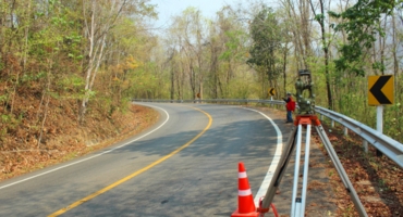
Our Services
3037
Railway Project Survey, Route Survey & Road Survey
Route Survey & Road Survey The term route survey refers to surveys necessary for the location and construction of lines of transportation ...
Read More...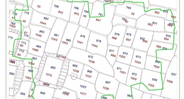
Our Services
13133
Mouza Map Pentagraph/Mouza Map Digitization (মৌজা ম্যাপ পেন্টাগ্রাফ/মৌজা ম্যাপ ডিজিটাইজেশন)
Mouza Map Pentagraph/Mouza Map Digitization (মৌজা ম্যাপ পেন্টাগ্রাফ/মৌজা ম্যাপডিজি�...
Read More...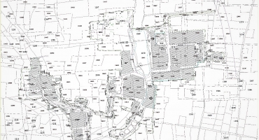
Our Services
7247
বাংলাদেশের যেকোনো প্রান্তের মৌজা ম্যাপ সরবরাহ করা হয় (Mouza map of any part of Bangladesh is provided)
বাংলাদেশের যেকোনো প্রান্তের মৌজা ম্যাপ সরবরাহ করা হয় (Mo...
Read More...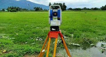
Our Services
3740
Digital Survey / Topographical Survey (টপোগ্রাপিক সার্ভে, ডিজিটাল সার্ভে, ভূমি/জমির ডিজিটাল সার্ভে)
Digital Survey CONTROL SURVEYS Control surveys provide horizontal and vertical positions of points to which supplementary surveys are adjusted. Contr...
Read More...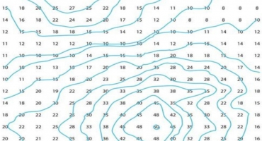
Our Services
3601
Contour Survey (কন্ট্যুর সার্ভে)
Contour Survey Contour line The line of intersection of a level surface with the ground surface is known as the contour line or simply the contou...
Read More...


CATEGORIES
PAGES
- Our Services
- Land Digital Survey / Topographical Survey / ল্যান্ড সার্ভে (ভূমি/জমির ডিজিটাল সার্ভে/ ডিজিটাল সার্ভে)
- SOIL TEST (সয়েল টেস্ট) & PILING (পাইল)
- Architectural Design (আর্কিটেকচারাল ডিজাইন) & As Built Plan (অ্যাজ বিল্ট প্ল্যান)
- Property Valuation প্রপার্টি ভ্যালুয়েশন (সম্পত্তির মূল্য নির্ধারণ করা)
- Valuation Certificate for Foreign Visa প্রপার্টি ভ্যালুয়েশন ফর ভিসা (ভিসা ফাইলের জন্য সম্পত্তি মূল্যায়ন)
- Flat & Floor Measurement অ্যাপার্টমেন্ট মেজারমেন্ট/ফ্লোর মেজারমেন্ট and Deviation Calculation
- Plotting and Layout (প্লাটিং / লে-আউট)
- Comparing Google Map, C.S., R.S. BRS Mouza Map & Identify land which is in possession on the map, Pantograph / Comparing Mouza Map মৌজা ম্যাপ পেন্টাগ্রাফ (মৌজা ম্যাপের উপর মৌজা ম্যাপ প্রতিস্থাপন), মানচিত্র/ মৌজা ম্যাপ ডিজিটাল ডিজিটাইজেশন
- GPS Survey (জিপিএস সার্ভে)
- Hydrographic Survey (হাইড্রোগ্রাফিক সার্ভে)